


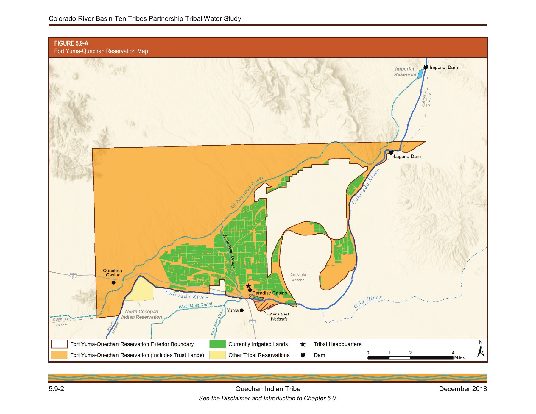
The December 2018 Quechan chapter of the Colorado River Basin Ten Tribes Partnership Tribal Water Study asks a different set of questions from the court documents. It describes the reservation's physical setting, water supply, uses, infrastructure, challenges, and possible future development. The result is a bridge between a decreed entitlement and the practical ways water supports agriculture, households, businesses, habitat, and community life. [1]
The chapter's descriptions of current use refer to its historical analytical baseline, including average annual use from 2009 through 2013. Its future scenarios extend beyond publication but remain projections built from specified assumptions. The chapter consequently offers two distinct kinds of information: an assessment of use during the baseline period and estimates of how that use might develop under alternative conditions. Neither constitutes a measurement of present-day deliveries.
That distinction gives the chapter its proper value. It is evidence of how the Tribe and study team assessed water development at a particular time, using legal records, accounting information, and planning assumptions. It does not supersede the decree, establish actual use in every later year, or guarantee that a scenario's envisioned investments and policy changes occurred.
The physical setting explains the water problem
The introduction places the reservation along the Colorado River near Yuma, spanning parts of Arizona and California and adjoining Baja California. It describes Interstate 8 crossing the southern area and the All-American Canal running through the reservation. The Tribe's headquarters are identified with the former Fort Yuma grounds in California, across the river from the city. [1]
The chapter also distinguishes the nearly level floodplain areas from rugged and mountainous portions and from lands at higher elevations above the canal. That physical variation matters to water delivery and agricultural development. A general acreage total cannot explain whether a particular part of the reservation has the same infrastructure, topography, or practical access to water as another.
The study's narrative connects the reservation to the Quechan people's broader ancestral homeland and to historical river-based agriculture. Those observations keep the federal reservation date from becoming the beginning of the people's history. The legal instruments define part of the administrative record; the study supplies a wider account of why the river mattered to settlement, food, and culture.
Rights and measured use appear separately
Table 5.9-A presents the decree-based diversion figures: 6,350 acre-feet annually in Arizona and 71,616 in California, totaling 77,966. It associates those figures with 952 and 10,742 net acres respectively and a January 9, 1884 priority date. Its note preserves the decree's qualification based on diversions or the corresponding consumptive-use requirement, whichever is less. [1] [2]
The table is not a report that all of that water was used in the study period. Later sections address actual or estimated use through different data. Separating the two is essential because an entitlement describes a legal framework, while an accounting or planning estimate describes activity under specified conditions and methods.
The chapter also discusses the California settlement mechanism involving Metropolitan separately from the decree table. The original agreements contain staged additional diversion terms and conditions for water becoming available to Metropolitan. Readers should follow those instruments and the study's explanation rather than combine numbers from different sections without regard to their legal and accounting roles. [3]
Agriculture dominates the reported uses
The study describes water for agriculture as primarily diverted at Imperial Dam and delivered through the Yuma Project's Reservation Division–Indian Unit. Other agricultural land receives water pumped directly from the river or from groundwater. Domestic uses are described as relying on groundwater. These differences show why one reservation-wide number cannot substitute for an account of delivery systems. [1]
For the 2009–2013 baseline, the study's table reports California agricultural diversions of 46,297 acre-feet annually and Arizona agricultural diversions of 224 acre-feet annually. These are historical averages as organized by the study, not current annual observations. The chapter also notes leasing of some tribal and allotted land to other farmers.
The agricultural account provides a practical counterpart to the older documents. The nineteenth-century agreement and reclamation laws dealt with making irrigable land productive; the study describes a much later system of canals, pumps, fields, and accounting categories. The connection is historical, but the study should not be read as proof that every earlier promise was fulfilled on the terms originally specified.
Domestic and commercial uses broaden the picture
The chapter describes water serving housing, tribal facilities, casinos, and other municipal and commercial demands. Its table separates domestic, commercial, municipal, and industrial use from agriculture, with distinct values by state. The California baseline diversion figure for that category is 795 acre-feet annually, while the table lists 30 for Arizona. [1]
This categorization matters because the reservation's water story is not confined to crop irrigation. The chapter situates farming alongside services, businesses, and a resident and seasonal population. Those uses place different demands on treatment, distribution, and planning than irrigation alone.
The figures remain tied to the study's period and method. They should not be used to infer present business activity, current population, or today's municipal demand. Their historical usefulness is that they show how the study divided and measured the reservation's uses when developing its assessment.
Water also supports habitat and cultural space
The chapter describes the Yuma East Wetlands restoration effort, begun in 2004, involving the Tribe, the City of Yuma, the Yuma Crossing National Heritage Area, and other agencies. It discusses removal of invasive vegetation, creation of backwater channels and marshes, and planting of native riparian vegetation. The project connects water use with habitat and public and cultural space. [1]
The study reports that the Tribe provided roughly 1,250 acre-feet annually for the wetlands project from its Arizona allocation. Its baseline table uses a separate environmental, cultural, and recreational category. The narrative estimate and table classification should be read in their respective contexts rather than assumed to be identical measures of a single year.
This part of the chapter is important because it shows beneficial uses that a narrow agricultural account would miss. The decree itself explains that an irrigation-based measure of quantity does not restrict all use to agriculture, subject to the stated consumptive-use limits. The study offers a concrete example of the broader planning context in which water is used. [2]
The baseline is a constructed analytical record
The chapter explains that its baseline combined Reclamation's Water Accounting Reports with information supplied by the Tribe. It expressly cautions against direct comparisons that assume the study and those reports contain the same data on the same basis. Consumptive-use estimates also relied on efficiency factors or engineering assumptions. [1]
That methodology matters when interpreting the table's total reported diversions of 61,646 acre-feet annually. The number is a study result assembled from specified sources and categories. It is not a raw gauge reading, a decree quantity, or an independently verified measurement of current use.
The distinction also helps readers understand why a planning study can be valuable without being definitive for every purpose. It organizes evidence to assess development and explore possibilities. The underlying accounting records remain important for questions about actual deliveries, return flows, and use during a particular reporting year.
Scenarios are alternatives, not promises
The future-development section considers current trends, slower development, and faster development under different assumptions about governance, funding, and settlement implementation. The faster-development alternatives include different levels of flexibility in off-reservation use. These are scenarios designed to explore a range of possible outcomes. [1]
A projection of increased agricultural use under one scenario does not establish that the increase occurred. Nor does a scenario assuming changed transfer rules prove that the legal framework changed as envisioned. The assumptions are part of the result and must remain attached to any figure quoted from the projection tables or graphs.
The chapter's discussion of constraints—including limits affecting transfers and off-reservation instream uses—helps explain why rights alone do not determine development. Infrastructure, financing, policy, and choices about use all influence what a community can do with an entitlement. The study examines those relationships as they were understood in 2018.
The alternatives also make clear that development is not treated as a single inevitable forecast. One scenario extends existing trends, another slows development through tighter constraints, and the rapid-development alternatives assume more favorable conditions. Comparing them is a way to explore consequences of assumptions, not a ranking of events already observed. The chapter's graphs should therefore be read as conditional paths from a historical baseline rather than as a verified timetable of later construction or use. [1]
A useful reference when its date stays visible
The chapter refers to the study's general disclaimer and introductory framework, placing its estimates and scenarios within the wider research design. Its tables combine reported information with analytical assumptions, while its maps describe the setting of the uses being considered. The chapter's conclusions depend on that framework and on the historical baseline. They describe the study's assessment, rather than a continuously updated account of conditions after publication. [1]
Read beside the decree and settlement, the chapter makes the water history more concrete. The legal documents establish and qualify rights; the study describes delivery, categories of use, and planning choices. The BIA map and the Tribe's location page add other geographic perspectives with their own purposes and limitations. [4] [5]
The chapter's contribution is therefore a dated, substantive account of water in practice. It shows how a legal entitlement connects to fields, homes, businesses, habitat, and possible future development. Keeping its baseline and assumptions visible allows readers to learn from that account without mistaking a historical study for a live report.
Sources
1. Colorado River Basin Ten Tribes Partnership Tribal Water Study, Chapter 5.9: Quechan Indian Tribe (December 2018). Tribal Water Study, chapter 5.9; sections 5.9.1–5.9.7 and tables 5.9-A and 5.9-B. Download PDF · Source publication · Source PDF (14 pages).
2. Arizona v. California, 547 U.S. 150 (2006), decree entered March 27, 2006. Article II(D)(3), definitions, and Appendix A. Read source PDF · Source publication
3. Arizona v. California, No. 8, Original, Special Master’s Approval of Final Settlements and Recommendations (June 14, 2005). California and Arizona agreements. Read source PDF · Source publication
4. Quechan Planning Map, July 6, 2017 (file date); marked DRAFT. Draft geographic and planning reference. Read source PDF · Source publication
5. Location, official tribal website; page updated August 11, 2025, retrieved October 25, 2026. Official tribal location description. Read source PDF · Source publication