


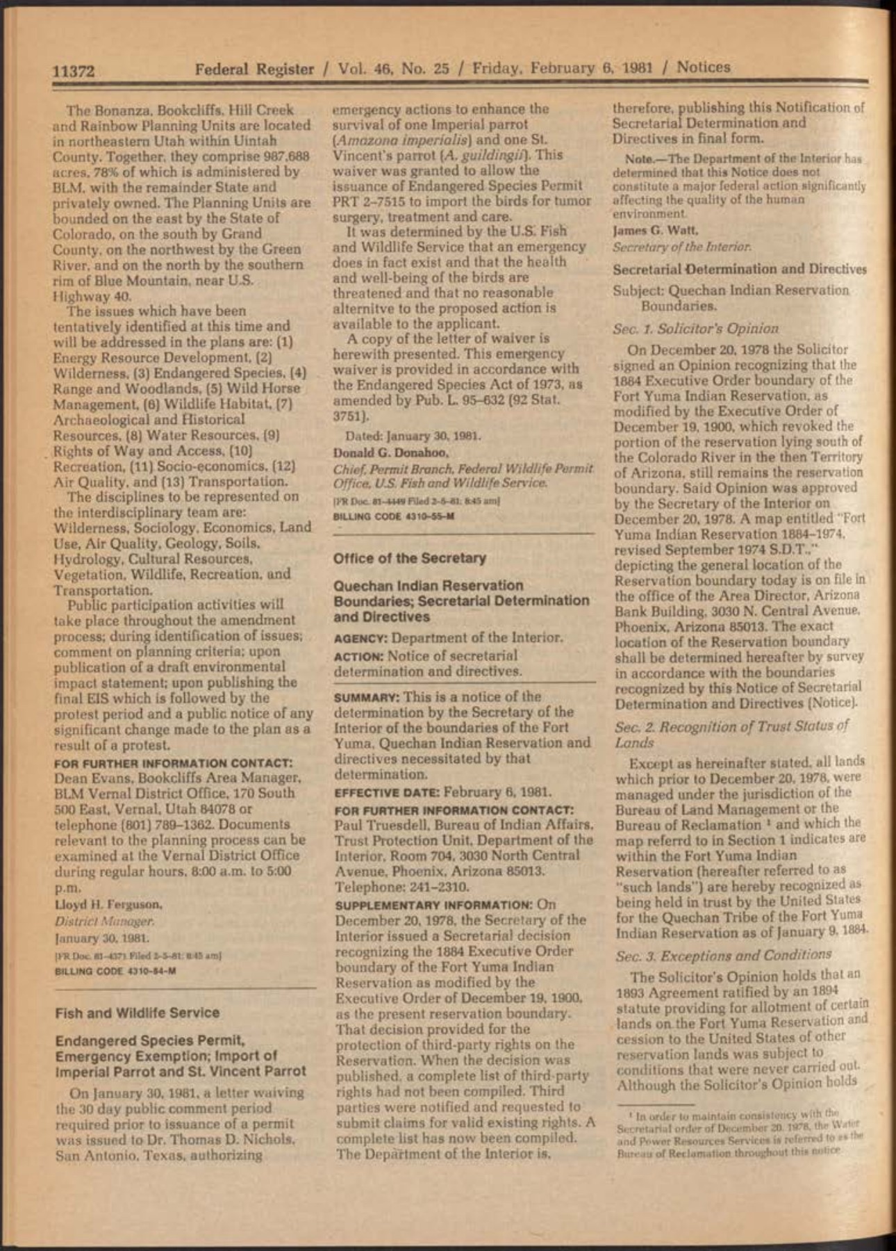
The February 6, 1981 Federal Register notice supplied a detailed published statement of Interior's determination concerning the Fort Yuma reservation. It recognized the reservation boundary described through the 1884 executive order as modified in 1900, affirmed the legal opinion underlying the 1978 action, and addressed trust status, exceptions, third-party interests, and administration. The document is considerably more specific than a headline announcing restoration of acreage. [1]
Its introductory explanation identifies why the determination was being reissued. When the Secretary acted in December 1978, the complete list of protected third-party rights had not yet been compiled. Third parties were notified and asked to submit claims for valid existing rights. With that compilation completed, Interior published the determination and directives with the more detailed treatment of interests. [1]
The notice was signed by Secretary James G. Watt on January 30, 1981 and published with an effective date of February 6. The signature, publication, and effective dates identify different aspects of the same record. The complete item runs through printed page 11,376, a continuation that is necessary to preserve the ending and signature.
The earlier legal conclusion is expressly carried forward
Section 1 affirms the Solicitor's opinion that supplied the legal foundation for the recognition. Krulitz had concluded that the 1893 agreement and 1894 statute provided for a conditional cession whose conditions had not been fulfilled. He also rejected the view that the later reclamation program completed the transaction. The published determination puts that reasoning into an administrative framework. [1] [4]
This relationship distinguishes the notice from a new stand-alone historical essay. It incorporates a prior legal conclusion and directs how Interior is to recognize and administer the resulting status. The opinion explains why the Department changed its position; the determination states the action and the conditions governing its implementation.
The notice's opening material also refers to the reservation boundary and an associated map available through the agency. That combination of textual orders, administrative recognition, and referenced geographic material is significant. The published account does not invite readers to infer the entire determination from a rounded acreage number alone.
The 1884 boundary and the 1900 modification
The reservation description rests on the January 9, 1884 order, with the modification identified in the December 19, 1900 order. The first established the California reservation and separately transferred the abandoned military reservation for Indian purposes. The second addressed the former military property south of the Colorado River and directed its disposition under specified statutes. [2] [3]
By identifying both orders, the notice incorporated the original reservation description and the later change involving former military property. The 1900 action concerned the portion south of the Colorado River; it did not cancel the entire reservation established in 1884. The combined reference therefore gave the 1981 determination a defined historical framework, acknowledging that the original arrangement had been modified in a particular respect.
It also demonstrates the difference between a historical boundary reference and a present parcel conclusion. The determination contains other provisions addressing interests within the recognized area. Its outer framework is important, but the legal account depends on the qualifications and directives that follow. A map showing only a perimeter would leave out much of the published determination.
Recognition of trust status
Section 2 addresses lands previously managed under BLM's jurisdiction within the reservation and recognizes them as held in trust by the United States for the Quechan Tribe as of January 9, 1884. That wording reflects the Department's conclusion that the conditional cession had not taken effect, rather than the idea that every acre was a wholly new acquisition created in 1981. [1]
The historical date in that recognition should be understood in connection with the opinion and the notice's exceptions. It does not mean that no intervening use, federal project, or third-party interest existed. The next section expressly deals with those matters. The recognition and its qualifications were published as a single determination.
This structure is important to the public explanation of the action. It identifies whose trust interest Interior recognized while acknowledging the legal and administrative landscape that had developed during the decades of a different federal interpretation. The result is more detailed than either a simple restoration slogan or a claim that all prior uses remained unaffected in every respect.
The schedule of third-party interests
Section 3 protects identified categories of third-party rights, including rights created under statutes predating the reservation and later interests established before December 20, 1978. The published list identifies permits, leases, rights of way, and other non-fee interests by instrument and administrative reference. Its specificity makes the notice useful evidence of what Interior included in the determination. [1]
The listed subjects include agricultural uses, utilities, roads, railroad interests, and facilities connected with water and power infrastructure. These are not a generic footnote saying that someone might have rights somewhere. The notice directs readers to the instruments that more particularly describe the interests. The distinction between a general listing and the underlying instrument remains important when examining any particular tract.
The schedule describes interests as they were addressed in the 1981 determination. It does not establish that every listed lease or permit continued indefinitely on identical terms. Later expiration, amendment, abandonment, or replacement would belong to the subsequent history of each instrument. The schedule's significance is its treatment of existing interests at the time Interior set out the terms for administering the recognized trust lands.
Reclamation works receive particular treatment
The notice separately addresses federal reclamation works and associated rights. It identifies facilities and references drawings that locate or describe them. This treatment recognizes that the land question intersected with a developed system of canals, levees, drainage, power facilities, and related access. The administrative action had to account for that system rather than speak only in terms of vacant acreage. [1]
One provision addresses reversion of equitable title for certain works and rights of way if they are abandoned or cease to be used for authorized reclamation projects, subject to stated exceptions and conditions. It also calls for surveys at federal expense, reporting to the Tribe, and referral of disputes to the Secretary. The precise terms matter; the provision is not an unconditional statement that every facility automatically reverts whenever a use changes.
The notice further reserves access needed for identified purposes and addresses material sites. It provides for payment of fair market value for materials removed from specified sites after the order and for periodic reporting. These administrative details show how recognition of title could affect continuing operations, compensation, and information-sharing, not merely the appearance of a reservation boundary on a map.
The determination also addresses floodplain use through a referenced drawing and a provision concerning consistency with the purposes of Executive Order 11988. That passage shows the administrative action connecting recognized interests with physical conditions and federal management requirements. The source supplies the historical provision; it is not a current determination of whether a particular development proposal satisfies every applicable rule. [1]
The drawing references locate particular works within that administrative framework. Some facilities are identified through specified drawings, while other appurtenances receive textual descriptions. The geographic operation of the determination consequently depended on more than the broad reservation outline. Its provisions joined legal recognition with the practical requirements of infrastructure already occupying or serving the area, including the supporting records used to identify individual facilities.
Other provisions preserve issues rather than erase them
The miscellaneous provisions include language preserving the Tribe's ability to seek whatever compensation might be determined appropriate in proceedings concerning past use of the lands. That clause matters because the recognition was not presented as a complete release of every potential claim arising from earlier administration or use. [1]
The determination also records tribal agreement to provisions through a referenced resolution. The notice's ending and signature are therefore substantive parts of the record. An excerpt ending before the final printed page could omit the closing relationship among the published directives, tribal agreement, and the Secretary's execution of the document.
The recognition of trust status operated within those accompanying provisions. Interior addressed existing interests, infrastructure, and reserved issues as part of administering the lands, rather than leaving them outside the determination. The notice therefore combined an important title-related conclusion with directions governing its implementation. Its practical consequences depended on the operative terms surrounding that conclusion.
A boundary determination within a larger litigation history
The Supreme Court's 2000 opinion explains that the Secretary's earlier administrative action had not been treated as a final determination of reservation boundaries for purposes of the earlier water decree. That procedural history is important when assessing what Interior's action accomplished and what questions remained in the interstate litigation. [6]
It does not make the determination meaningless. It shows that administrative recognition of land status and adjudication of additional water rights were related but distinct processes. Later proceedings addressed preclusion, disputed boundary claims, and negotiated water settlements. The 1981 notice belongs to that chain as a detailed administrative instrument, not as a substitute for the later judicial documents.
The original Federal Register pages preserve all four sections and the continuation through page 11,376. They allow readers to examine the recognition, the inventory of interests, and the implementation directions together. That complete view is the notice's principal value: it documents how Interior translated the 1978 reversal into a published framework for a reservation landscape containing tribal interests, private rights, and federal works.
Sources
1. 46 Fed. Reg. 11,372–11,376 (February 6, 1981); signed January 30, 1981. 46 Fed. Reg. 11,372–11,376; sections 1–4. Download PDF · Source publication · Source PDF excerpt (5 pages).
2. Executive Order of January 9, 1884; Executive Orders Relating to Indian Reserves (1902), p. 35. January 9, 1884 order. Read source PDF · Source publication
3. Executive Order of December 19, 1900; American Presidency Project web edition. December 19, 1900 modification. Read source PDF · Source publication
4. M-36908 (December 20, 1978), published at 86 I.D. 3–22 (1979). M-36908; 86 I.D. 3–22. Read source PDF · Source publication
5. Andrus Orders 25,000 Acres Restored to Quechan Indians’ Reservation (press release, December 21, 1978). December 1978 announcement. Read source PDF · Source publication
6. Arizona v. California, 530 U.S. 392 (2000). Administrative boundaries and subsequent water litigation; 530 U.S. 392. Read source PDF · Source publication