


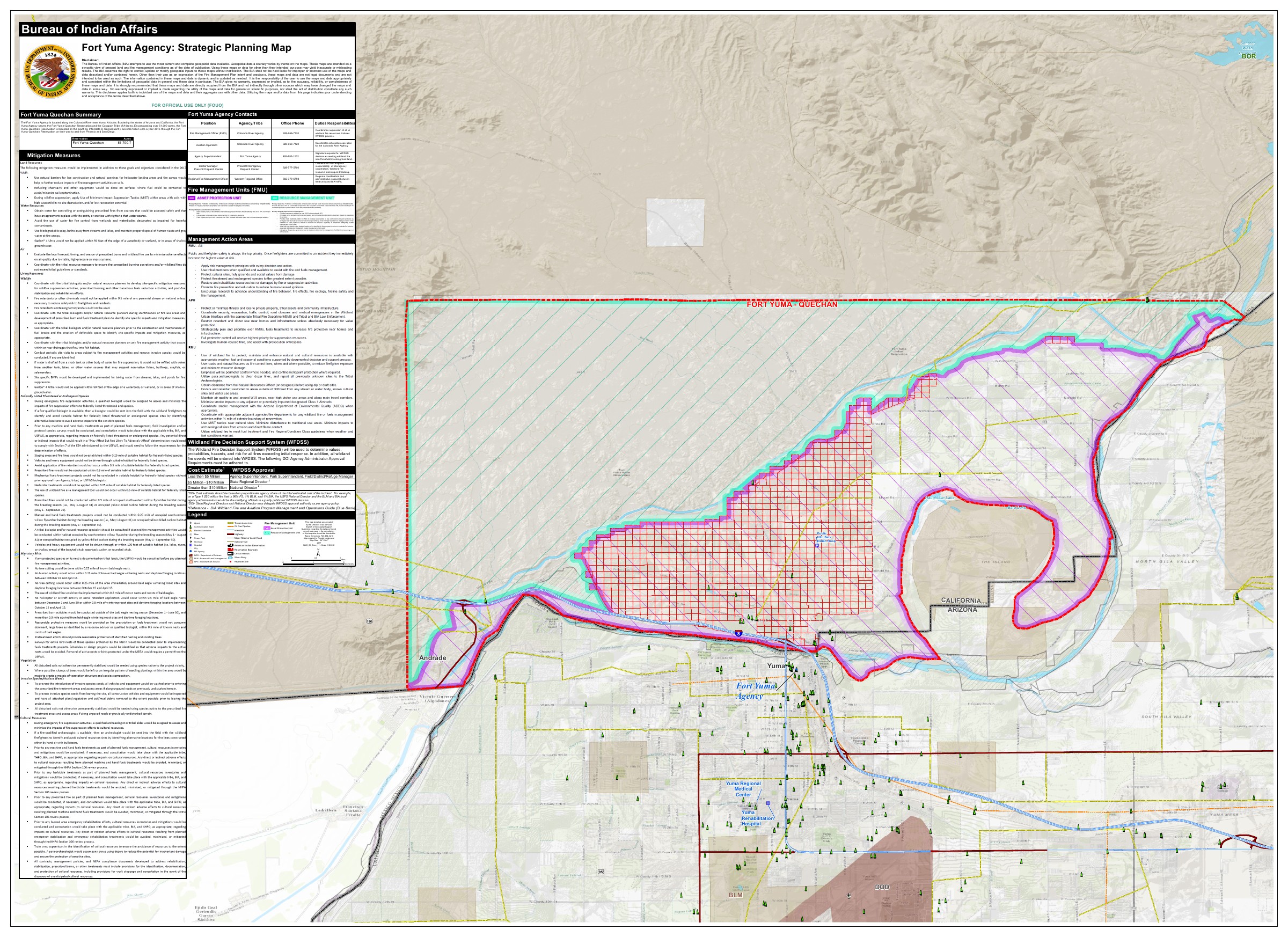
The BIA planning map offers a broad view of the Fort Yuma area: the Colorado River, roads, surrounding federal lands, infrastructure, and mapped reservation features appear together on a large sheet. Its purpose, however, is more specific than a general tourist map. The title identifies a strategic planning map for the Fort Yuma Agency, and the accompanying material concerns land and fire management. [1]
The map is prominently marked draft and carries an extensive agency disclaimer. That disclaimer explains that the sheet presents a dated overview of land and fire-management conditions, that the accuracy of different geographic themes varies, and that the map is not a legal document. Those statements define how the evidence should be interpreted; they are not markings to crop away when using the image.
The map places the reservation within a landscape of rivers, roads, canals, communities, and administrative responsibilities. Its geographic perspective complements the executive orders and boundary determination, which describe particular federal actions and their legal terms. The planning sheet serves a different purpose from a survey or title instrument: it brings multiple features of the landscape into one view for the agency's planning work. [4] [5]
A map assembled for a particular task
The sheet's supporting material identifies fire-management units, an asset-protection unit, and a resource-management unit. It also includes management-action information and a discussion of the Wildland Fire Decision Support System. These features distinguish it from a map prepared solely to display a reservation outline. [1]
A planning map selects and organizes information according to the decisions its users need to make. Roads, access, infrastructure, agency responsibilities, and features potentially affected by fire can all matter to that task. The resulting image brings together several kinds of geographic data that may have different sources, update cycles, and levels of precision.
The agency's disclaimer acknowledges variation among the mapped themes. It describes a dated overview and warns that uses outside the intended purpose may be inaccurate or misleading. That qualification is part of the map's character as a planning document. Its combination of information from different categories can show relationships across the landscape without establishing a single, legally definitive boundary for every feature it depicts.
The legend shows what the map considers relevant
The legend identifies transportation features, transmission lines, pipelines, communication infrastructure, power facilities, water bodies, federal land-management categories, and reservation features. It also identifies critical habitat and other mapped themes. The sheet therefore portrays a working landscape in which different systems and jurisdictions meet. [1]
That perspective is useful alongside the historical documents. The 1981 determination, for example, addresses rights of way, utilities, reclamation works, and access within the recognized boundary. The planning map makes it easier to understand why such categories appear in a land-status document: the reservation area contains infrastructure and uses that cannot be represented adequately by a single outer line. [5]
The connection is explanatory, not a claim that every symbol corresponds to one particular listed legal interest. A map legend tells readers how features are represented on the sheet. The legal status of a specific facility or tract depends on the relevant instrument and subsequent history, which the symbol alone does not establish.
The legend's separation of BLM, National Park Service, and Defense Department lands further emphasizes the regional character of the sheet. It places the reservation in relation to surrounding federal management categories rather than presenting it as an isolated shape. Those categories are useful orientation, but a planning legend does not determine the legal effect of each historic grant or reservation. The distinctions shown on the map and the instruments underlying them remain different layers of evidence. [1]
The river connects the historical record to place
The Colorado River connects several stages of the reservation's documented history. It appears in the original boundary descriptions, the military-property modification, irrigation plans, and later water-rights proceedings. The regional view places those recurring references within the surrounding terrain and infrastructure. The same river that defined portions of earlier descriptions also supplied the water whose use became the subject of later planning and litigation. [3] [4] [5]
The 2018 study adds physical context by describing the reservation's floodplain, uplands, canals, and varying elevations. Its account explains why agricultural land, water delivery, and the area's infrastructure are closely connected. The planning map supplies a complementary visual view, while the study provides a dated narrative and data framework. [3]
Neither source turns the river into an unchanging line outside time. Historical documents can refer to channels, former beds, surveys, or particular dates. The map offers its own representation for its planning purpose. Comparing it with an older instrument therefore requires attention to date and function rather than assuming every depiction must answer the same geographic question.
The acreage figures do not all match
The map's summary lists 51,700.7 acres for Fort Yuma–Quechan and describes more than 51,000 acres. The Tribe's location page and the 2018 water-study introduction describe a reservation encompassing 45,000 acres. These are different reported figures in different sources. [1] [2] [3]
The difference among the acreage figures does not by itself establish an addition to or loss of reservation land. The cited references do not explain whether their totals use identical definitions, geographic inputs, or land categories. Each figure belongs to a dated document prepared for a particular purpose. Without that underlying comparison, the numerical difference cannot be assigned a specific historical cause.
The map's decimal acreage value is more numerically precise than the rounded figure in the public location description, but precision alone does not establish legal authority or identical measurement. The planning sheet's own disclaimer limits what can be concluded from its geographic themes. The figures show a difference in published descriptions; they do not supply a parcel-by-parcel explanation of that difference. [1] [2] [3]
Scale and presentation affect what can be inferred
The sheet identifies a 1:38,000 scale and a large original page format. That tells readers something about the level at which the map was intended to be viewed. Reducing it to a small webpage image can make labels, symbols, and qualifications difficult to read even when the overall geographic impression remains clear. [1]
The legend and supporting text are integral to the map's meaning. They identify which symbols represent infrastructure, land-management categories, water features, and other themes. The geographic image alone cannot convey every qualification carried by those descriptions. The sheet's planning value comes from the combination of mapped relationships and explanatory information, with the stated limits applying to the document as a whole.
Scale also limits what a visual inspection can establish. A regional planning sheet can orient a reader to an area or feature without resolving a parcel boundary on the ground. The reservation's legal description, cadastral surveys, and particular grants or reservations of interest remain separate evidence for that more specific inquiry. [4] [5]
Agency information is a dated snapshot
The map includes a contact and responsibility table for agency functions, together with fire-management decision information. Those entries situate the sheet within the agency's planning work in 2017. They describe responsibilities as recorded at that time rather than establishing a present staffing or emergency-response directory. The operational information helps explain why the map combines landscape features with administrative categories. [1]
That distinction avoids a practical mistake as well as a historical one. The map is being preserved as a source document, not republished as an operational directory. Its value is to show what information the agency assembled for the plan and how it described responsibilities at that time.
The draft marking and agency handling labels identify the status in which the map was issued. They accompany the disclaimer about its purpose and accuracy. Those elements distinguish a planning sheet from a final legal survey, even where both might depict some of the same terrain. The document's status is therefore relevant to its interpretation alongside the date, legend, and geographic information. [1]
A comparison with the 1894 maps
The earlier Senate transmittal also includes maps, but they accompanied a different project: consideration of the Yuma agreement and the agricultural works expected to support it. The surrounding correspondence discussed proposed canals, flood protection, surveys, and uncertainties in the engineering information then available. [6]
Comparing the two sets of maps is useful because it shows different administrative purposes across time. The 1894 packet helps explain a proposed land-and-irrigation arrangement. The 2017 sheet assembles land and fire-management information. Both can enrich a historical narrative, but neither should be detached from the report or qualifications that explain what its makers were trying to represent.
The comparison reveals continuity in the subjects being mapped and change in the purposes of mapping. River conditions and infrastructure mattered to nineteenth-century irrigation planning and also appear within the later agency landscape. The documents were produced for different decisions, however. Their respective legends, dates, and qualifications determine what each can establish about the reservation at its own historical moment. [1] [6]
The landscape as a planning subject
The 2017 sheet broadens the story beyond a sequence of legal texts. It shows a reservation area connected to transportation corridors, water infrastructure, public facilities, surrounding land-management units, and environmental features. Those relationships help make the abstract categories in the historical documents more concrete. [1]
Its contribution remains a planning view, not a new act establishing or adjudicating the reservation boundary. The 1884 order and 1981 determination explain different parts of that legal history; the Tribe's location page supplies a public description; and the 2018 study supplies another dated account of geography and water use. Reading these sources together preserves their complementary roles without pretending they are interchangeable. [2] [3] [4] [5]
The map is most useful when its whole sheet remains available: image, legend, summary, and qualifications. Readers gain a clearer sense of place while retaining the information needed to understand exactly what kind of evidence they are looking at.
Sources
1. Quechan Planning Map, July 6, 2017 (file date); marked DRAFT. Fort Yuma Agency strategic planning map; legend, summary, and disclaimer. Download PDF · Source publication · Source PDF (1 page).
2. Location, official tribal website; page updated August 11, 2025, retrieved October 25, 2026. Official tribal location page; displayed update August 11, 2025. Read source PDF · Source publication
3. Colorado River Basin Ten Tribes Partnership Tribal Water Study, Chapter 5.9: Quechan Indian Tribe (December 2018). Sections 5.9.1–5.9.3 and reservation map. Read source PDF · Source publication
4. Executive Order of January 9, 1884; Executive Orders Relating to Indian Reserves (1902), p. 35. Original California reservation description. Read source PDF · Source publication
5. 46 Fed. Reg. 11,372–11,376 (February 6, 1981); signed January 30, 1981. Boundary determination, exceptions, and directives. Read source PDF · Source publication
6. S. Exec. Doc. No. 68, 53d Cong., 2d Sess. (March 21, 1894). Historical maps and accompanying engineering correspondence. Read source PDF · Source publication